|
RADIOACTIVE CONTAMINATION OF THE TERRITORIES OF SEMIPALATINSK TEST SITE INVESTIGATION (1989-1990)
In 1990-1991 the specialists from Laboratory of Environmental Radioactivity (MEPhI)
took part in the joined Semipalatinsk Test Site (STS) territories radioactive contamination
investigations. The Laboratory task was to conduct the airborne survey of the territories
of interest to construct the artificial and natural nuclide activity maps. The results
obtained were displayed in the corresponding reports and some of these results were published.
The airborne survey results extract of the article by Dubasov Y.V., Krivokhatskiy A.S.,
Filonov N.P., Kharitonov K.V. "Radiation conditions beyond the bounds of Semipalatinsk
nuclear test site" published in "The Atomic Energy Bulletin N.9 1993. Moscow" is adduced here.
You may find full text of this article here (263 KB).
<<...
In 1990-1992 the radiation contamination investigation of the Semipalatisk Test Site surrounding
territories was conducted by means of ground-based and airborne equipment. The following parameters
were measured: dose rate, ground surface and vegetation radionuclide contamination, 137Cs and
90Sr concentration in water, the radioactive atmospheric aerosol and indoors radon concentrations.
A great amount of investigations was accomplished in the villages (Dolon, Kaynar, Sarzhal, Caraaul,
Mostic, Mayskoe, Egendibulac and Chagan) near the test site borders. More than 30000 km2
of the territories of interest were surveyed by airborne and ground-based equipment (see scheme below).
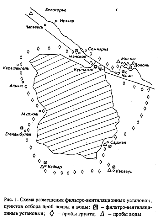
The detailed measurements were carried out in Dolon, Mostic, Kaynar, Sarzhal and Caraaul
villages. Being disposed 100-200 km far from the surface nuclear tests these villages were more than the others
influenced by radioactive fallouts...
...The airborne survey of the villages and test surrounding territories was conducted by
two organization:
- Laboratory of Environmental Radioactivity of Moscow Engineering Physics Institute
- Comprehensive Airborne survey expedition of "Aerogeologiya"
by means of their equipment and methods. The MEPhI data are half as many "Aerogeologiya" data.
That is because the contamination values are not far from the equipment sensitivity and different
survey methods were used: the villages were the territories of interest for MEPhI and the rather big
territory including the villages was the zone of interest for "Aerogeologiya".
The ground-based survey of the villages was conducted by the Khlopin Radium Institute
and Ministry of Defense specialists. The detailed in-situ dose rate measurements were conducted.
The ground, water and vegetation samples were measured later in laboratory conditions.
The results obtained are presented in Tables 1-2. The MEPhI airborne survey results
are in good agreement with ground-based survey data.
Table 1
137Cs surface activity according to airborne survey
Village |
Distance from STS, km |
137Cs surface activity, Ci/km2 |
by MEPhI |
by "Aerogeologiya" |
Kaynar |
130 |
0,07-0,1 |
0,3 |
Sarzhal |
110 |
0,12-0,14 |
0,3 |
Caraaul |
200 |
0,09-0,12 |
0,2 |
Egendibulac |
115 |
0,05-0,07 |
- |
Table 2
Surface activity according to in-situ and laboratory measurements, Ci/km2
Village |
Dose rate, mR/h |
137Cs surface activity |
90Sr surface activity |
239+240Pu surface activity |
Dolon |
21/10 |
0,29/0,02 |
(0,012) |
0,3/0,014 |
(0,05) |
0,3/0,001 |
(0,093) |
Kaynar |
20/13 |
0,3/0,03 |
(0,12) |
0,14/0,02 |
(0,05) |
0,028/0,0006 |
(0,01) |
Sarzhal |
20/13 |
0,3/0,05 |
(0,12) |
0,26/0,04 |
(0,07) |
0,1/0,0003 |
(0,028) |
Caraaul |
18/10 |
0,37/0,008 |
(0,08) |
0,19/0,02 |
(0,06) |
0,032/0,0006 |
(0,009) |
Mostic |
18/12 |
0,13/0,02 |
(0,06) |
0,06/0,02 |
(0,04) |
0,082/0,0006 |
(0,022) |
* Numerators - maximum value, denominators - minimum value, in brackets - averaged values.
...>>
As far as the extract adduced above is concerned we are to say the following.
First. The 137Cs contamination values of the villages (Table 1) were identified
by means of Ge detector based airborne gamma-spectrometer.
Second. The MEPhI specialists presented the 137Cs contamination values of the
villages as Ą±DĄ, where Ą and DĄ are the value
and its uncertainty. For unknown reasons the MEPhI data were somewhat uncorrectly transformed.
Third. We regard the explanation of 2-2.5 times discrepancy between ground-based survey and
"Aerogeologiya" results being a highly debated one.
Below are shown some airborne artificial nuclide activity maps for the territories surveyed.
These results were not included in the paper quoted. Nevertheless we suppose them being very interesting
to gain the idea of the territories surveyed contamination and to demonstrate the MEPhI designed airborne
technologies.
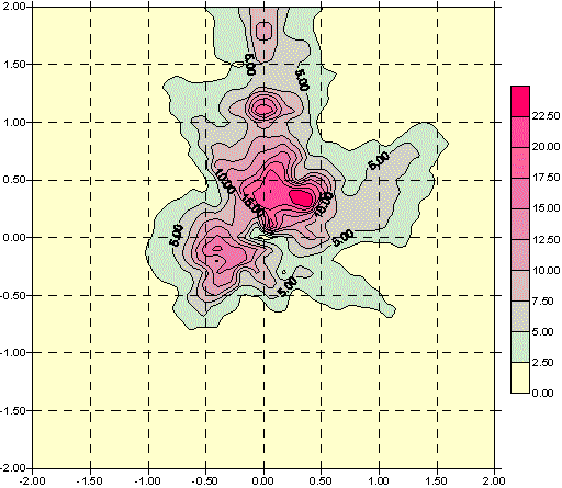
137Cs spatial distribution at 1004 object
(artificial lake on Chagan river), Ci/km2.
60Co spatial distribution at 1004 object
(artificial lake on Chagan river), Ci/km2.
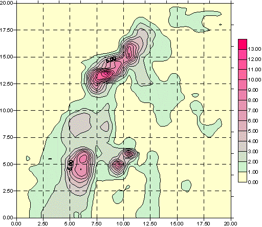
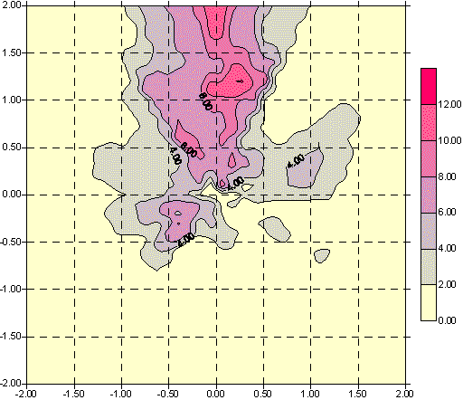
137Cs spatial distribution
at some test place, Ci/km2.
137Cs spatial distribution at Caraaul village, Ci/km2.
Return to the homepage...
|